Showing posts with label selangor. Show all posts
Showing posts with label selangor. Show all posts

Mee Udang Kuala Selangor Vs ABC
 |
| mee udang |
 |
| mee udang banjir |
…Inilah alamat
MEE UDANG BANJIR KUALA SELANGOR :-
* MEE UDANG BANJIR,
LOT 652 KM 1 OFF JALAN KLUANG, KUALA SELANGOR
DEPAN MASJID JAMEK SULTAN IBRAHIM K. SELANGOR
0196644235(HJ BAHARUDIN)
Kesimpulannya….. MEE UDANG BANJIR yang kitorang makan kat
Tanjung Karang( masuk JJCM ) taste better laa…. siap makan dengan
otak-otak lagi.Yang penting rasa seronok apabila berpeluang makan
bersama dengan keluarga…..
Alamat gerai MEE UDANG BANJIR KUALA SELANGOR :-
* MEE UDANG BANJIR,
LOT 652 KM 1 OFF JALAN KLUANG, KUALA SELANGOR
DEPAN MASJID JAMEK SULTAN IBRAHIM K. SELANGOR
0196644235(HJ BAHARUDIN)
 |
| Air Batu Campur (ABC) |
Air batu campur ataupun lebih terkenal sebagai ABC (juga dikenali sebagai Ais Kacang di Pulau Pinang dan Singapura). Diasaskan daripada Shave Ice yang berasal dari Jepun. Ia boleh juga didapati di negara lain seperti Amerika, Filipina, Thailand dengan nama lain seperti snow ice dan sebagainya.
Ia merupakan sejenis minuman yang diperbuat daripada ais yang dimesin dan dicampur dengan bahan-bahan seperti kacang, buah kabung, cendol, cincau, jagung, pemanis, seperti sirap dan sarsi serta air nisan.
Ia menjadi pilihan utama bagi penggemar mahupun cuaca sejuk atau panas
Malaysia Signboard Today
 |
| berhenti |
 |
| Stop |
 |
| Sas Corner |
 |
| UMW |
The main purpose of a signs is to communicate, to convey information such that its receiver can make cognitive decisions based on the information provided. In general, signs can be classified into the following functions:
(a) Information: signs giving information about services and facilities, e.g., maps, directories, instructions for use, etc.
(b) Direction: signs leading to services, facilities, functional spaces and key areas, e.g., sign posts, directional arrows, etc.
(c) Identification: signs indicating services and facilities, e.g., room names & numbers, toilet signs, number of floors, etc.
(d) Safety and Regulatory: signs giving warning or safety instructions, e.g., warning signs, traffic signs, exit signs, rules & regulations, etc.
Signboard Malaysian Style 2013
 |
| japan,australia... |
 |
| Rumah 4 musim |
 |
| Peta is map |
 |
| Skytrek Bus Stop |
 |
| Exit Way |
 |
| Slippery |
 |
| What Zone |
 |
| That Rules |
 |
| Main Maps |
Road signs in Malaysia are standardized road signs similar to those used in Europe but with certain distinctions. Until the early 1980s, Malaysia closely followed Australian and Japanese practice in road sign design, with diamond-shaped warning signs and circular restrictive signs to regulate traffic. Signs usually use the FHWA Series fonts (Highway Gothic) typeface also used in the United States, Canada, and Australia, although some signs on recently completed expressways use Transport Heavy (cf. the second image shown to the right).
Malaysian traffic signs use Malay, the official and national language in Malaysia. However, English is also used for important public places such as tourist attractions, airports, railway stations and immigration checkpoints. Both Malay and English are used in the road signs that are located along the Pengerang Highway (Federal route ), which links Kota Tinggi to Sungai Rengit in Johor state and Genting Sempah-Genting Highlands Highway which links Genting Sempah to Genting Highlands.
According to the road category under 333 Act, the Malaysian Road Transportation Act 1987, chapter 67, blue traffic signs are used for federal, state and municipal roads. Green signs are used for toll expressways or highways only. State roads use letters. For example, Negeri Sembilan N70, Melaka M5 , expressways use letters E, and cycle roads use letters CR. Federal Roads only use numbers and digits, for example Federal Route . However, federal road numbers can also be added with the prefix before the route number, which is normally used by the Malaysian Public Works Department (JKR) and Malaysian police. For example, Federal Route can also be written as Federal Route .3
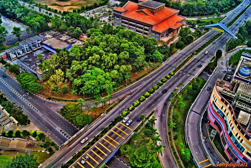
Shah Alam Landscape View
 |
| Shah Alam |
 |
| Shah Alam Sunrise |
 |
| Shah Alam View HDR |
 |
| Shah Alam HDR |
 |
| Shah Alam Sunset |
 |
| Plaza Alam Sentral |
 |
| Shah Alam Town City |
 |
| Shah Alam BW |
Shah Alam is the state capital of Selangor, Malaysia situated within the Petaling District and a small portion of the neighbouring Klang District. It is located about 25 kilometres west of the country's capital, Kuala Lumpur. Shah Alam replaced Kuala Lumpur as the capital city of the state of Selangor in 1978 due to Kuala Lumpur's incorporation into a Federal Territory in 1974. Shah Alam was the first planned city in Malaysia after independence from Britain in 1957.
Malaysia grew rapidly after its independence in 1957 under the "Father of Modernisation", the second Prime Minister of Malaysia, Allahyarham Tun Abdul Razak Hussein. Shah Alam was once known as Sungai Renggam and was noted for its rubber and oil palm estates. Later, the same area was identified as Batu Tiga prior to Malaysian independence, and has been a centre of rubber and palm oil trade for centuries. The Sungai Renggam Plantation was earmarked for the development of a township by the Selangor government in 1963, and under the recommendations of V. Antolic, a town planning advisor from the United Nations, chose the present site strategically located between Kuala Lumpur and Port Klang.
Its current name was chosen by the then state Sultan of Selangor, Sultan Salahuddin Abdul Aziz Shah, after his late father Sultan Alam Shah. Many other monuments, buildings and even a street are named after the late Sultan. Shah Alam was opened in 1963 with the purpose of making it the administrative centre of Selangor once Kuala Lumpur was made a Federal District on 1 February 1974. With the consent of 8th Duli Yang Maha Mulia Sultan of Selangor, Almarhum Sultan Salahuddin Abdul Aziz Shah Al-Haj, Shah Alam was proclaimed the capital of Selangor on 7 December 1978 with an area of 41.68 square km, and administrated by a municipal council. Shah Alam had encountered several processes of extending its areas and the last was on 1 January 1997. Through the Gazette Plan 1190, Shah Alam was extended to 293 square km
Shah Alam was granted city status on 10 October 2000 with Dato' Haji Abu Sujak Haji Mahmud as the first mayor. He recently served as deputy Menteri Besar, or Chief Minister of Selangor. Abu Sujak declared the vision of making Shah Alam a modern city with a unique identity of "Bandaraya Melayu" or Malay City, showcasing the achievements of the Malay race in all sectors. In line with this identity, Shah Alam was declared the first city in the world with no entertainment outlets to avoid any vice activities.
Shah Alam is located within the district of Petaling and a portion of the district of Klang in the state of Selangor. Due to its recent expansion, it is bordered by the cities of Subang Jaya and Petaling Jaya in the east, the district of Klang in the west, the district of Kuala Selangor and Selayang in the north, and the district of Kuala Langat in the south. Shah Alam is also one of the major cities within the Klang Valley, an area in Malaysia comprising Kuala Lumpur and its suburbs, and adjoining cities and towns in the state of Selangor, due to the Klang River flowing through it on its way westward to the Strait of Malacca.
Shah Alam has a similar urban layout to Petaling Jaya or Subang Jaya with housing areas occupying most of the city (55.2 km2) and commercial centres scattered around the different 'Seksyen' (sections).[citation needed] There are 56 sections in total. Generally Shah Alam can be divided into north, central and south part. North Shah Alam consist of 18 Sections including Sections U1 and U2 and Kampung Melayu Subang. The Central Shah Alam is the 'main' part of Shah Alam. It is where all the state administrative building and agencies are situated. It consist of Section 1 until Section 24 seen in the map as beige coloured area. South Shah Alam consists of 12 sections including Section 25(Sri Muda), Section 30 (Jalan Kebun), Section 31 (Kota Kemuning) and Section 32 (Bukit Rimau). In the map, the south Shah Alam is seen as the light purple coloured area.
The city has a number of shopping malls (Plaza Alam Sentral, (also known as PAS), SACC Mall, Plaza Shah Alam (formerly known as Shah Alam Mall, also known as Plaza Masalam), Ole-Ole Seksyen 18, Anggerik Mall and Kompleks PKNS). Vibrant commercial areas are situated mostly at the city centre (Seksyen 14), Seksyen 13 and Seksyen 9. There are no cinemas in the city.
All of the main roads and streets in Shah Alam including the new townships such as Setia Alam and Kota Kemuning have signs with their names shown in both Roman and Jawi scripts.
See also List of sections in the city shah alam
Subscribe to:
Comments (Atom)
LinkWithin
